Tag Archives: Clean Water Rule

The Environmental Protection Agency definition of “water of the U.S.”

The Science Behind the 2023 WOTUS Rule

No, regulation of the Waters of the United States (WOTUS) is not my favorite topic to write about, even though I’ve now completed seven posts on the subject.  The most I have written on any topic, because it has been and will ever be a never ending battle between the forces of science and the forces of development. Developers want to limit the application of Clean Water Act (CWA) regulations to “nonproductive” wetlands and upstream waters so they can infill them and use the land for houses, mines, agricultural fields, etc. Scientists though understand that the hydrologic cycle pretty much means every drop of water on earth is connected to every other drop of water and development in these supposedly disconnected wetlands and upstream waters will impact downstream waters considered to be WOTUS.

            Scientific investigations continue to confirm the scientists viewpoint, including the recent Technical Support Document (TSD) for the 2023 WOTUS Rule now on top of the ash heap of Supreme Court Decisions. See my post from earlier this year if you want to know more (Supreme Court Decision on Waters of the United States ).   I took up the TSD to see what new investigations have been conducted in support of the scientific viewpoint since the last great U.S Environmental Protection Agency (EPA) treatise on the subject in 2015 entitled “Connectivity of Streams and Wetlands to downstream Waters: A Review and Synthesis of the Scientific Evidence.”  Here’s a link to my post on the 2015 Report (A Review of the EPA’s Connectivity of Streams and Wetlands  ) if you want to do some catching up.

            It has been eight years now since the 2015 Report so let’s see what recent studies the 2023 TSD cites in support of the global connectivity of water.  EPA found 2,022 peer reviewed scientific papers published since 2015 relevant to the 2023 rulemaking.  Scientists have been busy.  Nothing spurs scientific investigation like a controversy and there was a lot of that after the 2015 Report was released.  The 2015 Report supported a widely unpopular WOTUS Rule regulating upstream waters and wetlands. The 2023 TSD documentation mirrors the earlier 2015 report.  It is divided into three areas of scientific investigation:

  • Ephemeral, intermittent and perennial streams
  • Floodplain wetlands and open waters
  • Non floodplain wetlands and open waters

The largest number of new investigations (986) concern ephemeral, intermittent and perennial streams.  There’s a reason for this.  It was the most controversial part of the 2015 regulation.  Ephemeral streams are those that flow only briefly usually as a result of localized rainfall.  Intermittent streams are those that flow seasonally.  Perennial streams have continuous flow.  It seems natural to most people that ephemeral and intermittent streams are not impacting downstream WOTUS much, but the people who live near these types of streams and are dependent on them think otherwise.  Many of these water bodies are in the western part of the U.S. and they are often important upstream waters for protecting downstream water quality.  When the Rule supported by the 2015 Report was pulled by the EPA, the first groups to sue were Indians tribes.  As a result many scientists wanted to investigate how these ephemeral and intermittent streams are acting as headwaters for downstream flows and water quality.  Ephemeral streams make up 48 percent of the stream length of all streams in the lower 48 states.  That’s a pretty big number.  The flow in ephemeral streams from precipitation events can have major effects on downstream waters due to abrupt increases in water that transport sediment, wood and other materials. 

Although their stream beds may visually appear dry, they still have water flow in the hyporheic zone (the stream bed lying below the surface.)  EPA cites Gallo and others in a 2020 study showing ephemeral and intermittent streams are providing valuable groundwater recharge from the hyporheic zone. Although ephemeral and intermittent streams might have observable flow only 1 to 82 % of the time, the presence of water in the hyporheic zone exists 4 to 33 times longer. 

Other studies cited by EPA include those of Covino and Magliozzi in 2018 showing ephemeral and intermittent steam without surface flow have complex and abundant hyporheic flow that maintain a downgradient hydrologic connection by supplying surface flows and maintaining habitat.

The second largest number of publications covered investigations of floodplain wetlands (660 scientific papers).  The 2015 Rule pretty much included all floodplain waters as being WOTUS. in its definition of what an adjacent covered wetland to a WOTUS is.  Of course that Rule was pulled in 2020 and the new rule that came in restricted what could be regulated as an adjacent wetland. 

Floodplain wetlands are actually part of stream and river systems with intricate connections, interactions and exchanges with them.  For example when river banks overflow during floods, floodplain wetlands serve as overflow storage.  Also there is a groundwater connection between a surface water body and it’s floodplain wetlands.

EPA cites a paper by Webb and others published in 2017 that shows how flood inundation of wetlands surrounding a surface water body contributes 72 to 76 percent of groundwater discharges to rivers. Simultaneously these inundated wetlands are being provided nutrient rich waters from the flooding stream systems.  It’s a sort of symbiotic relationship.  One can’t be disconnected from the other without impacts to both.  So if you infill a wetland, the flows that feed downstream surface waters are diminished and the nutrient sink that is the wetland is gone. Nutrients like nitrogen and phosphate are free to flow into surface waters where they can, as we all know, create a bunch of havoc.  In fact Gordon and others in 2020 showed that floodplain wetlands remove an average of 200 kilograms of nitrogen per hectare over a years time and 21 kilograms of phosphate.

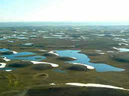
Non floodplain wetlands had the fewest number of scientific investigations at a disappointing 491 published papers   Non floodplain wetlands are often dismissed by just about everyone as unimportant and “nonproductive”. These are waters like prairie potholes.  The research that has been conducted since 2015 is pretty conclusive as to the connectivity of these isolated wetlands with WOTUS even if a great part of the connection is to keep surface runoff from reaching downstream waters. 

These non floodplain wetlands comprise 16 percent of all wetlands in the lower 48 states by areal extent.  A huge number still considering how many have been infilled for all types of development.  EPA cites a literature review by Lane and others of all studies of non flood plain wetlands.  Their paper shows these isolated waters are all interconnected in some way to river systems, either through storing storm waters so they aren’t washed along with a bunch of nutrients downstream or serving as a source of base flow of groundwater to rivers during dry periods.  Another study cited by EPA is that by Thorslund and others who conducted an investigation in 2018 using chloride tracers to study how non floodplain wetlands in Florida contribute surface water to downstream river and streams. The study showed nonfloodpain wetlands are a watershed scale source of flow for  90 percent of Florida’s headwater streams.

The TSD also cites Brooks and others who performed a similar trace study using isotopes in North Dakota. The researchers found significant amounts of water from isolated wetlands are providing water to downgradient perennial streams.  Rains and Cohen both published papers in 2016 showing how non floodplain wetlands can attenuate surface water flow and provide storage on a watershed scale that helps prevent devastating floods.

Also like the floodplain wetlands, studies have shown non floodplain wetlands to be a dramatic reducer of nitrates, phosphates and carbon.  Cheng and Basu in 2017 showed that 50 percent of nitrogen removal across all water bodies occurs in small wetlands and Evenson and others. in 2021 found through watershed modeling that restoring just 2 percent of non floodplain wetlands in the Upper Mississippi basin would result in a 12 percent nitrate reduction.  This would be an amazing achievement if it could be done to help eliminate the dead zone in the Gulf of Mexico caused by unchecked nutrients washing off farm lands into the Mississippi River.

So I guess I can say in summary that scientists have advanced the state of knowledge of how ephemeral and intermittent streams as well as non floodplain and floodplain wetland are connected to traditional downstream WOTUS.  EPA goes as far as to say that “after analyzing the abstracts of all 12,659 papers published since 2014, the evidence is conclusive that ephemeral, intermittent and perennial stream, floodplain wetland and non floodplain wetlands are hydrologically, chemically, biologically and functionally connected to downgradient waters.”  The EPA has also calculated the value of these type of headwaters through their benefits to society including fishing, hunting, boating, bird watching, religious uses, production of fuel, forage and fibers, extraction of materials for biofuels, food such as shellfish, and medical compounds.  The dollar value assigned to headwater streams is $15.7 Trillion annually and that calculated for non flood plain wetlands is $673 Billion annually.  This looks to me like a pretty significant economic contribution from a bunch of upstream waters that people have been dismissing as “non-productive”.
Supreme Court Decision on Waters of the United States

What is the difference between “adjoining” and “adjacent”?  The difference in the definition of the two words is what it all came down to in the May 2023 Supreme Court decision on the inclusion of wetlands in the Clean Water Act’s (CWA) definition of the Waters of the United States (WOTUS). The letter of the law in the CWA is “it is unlawful to discharge dredged or fill material into “navigable waters” of the United States, tributaries of such waters and adjacent wetlands.”

Judge Alito in his Opinion says “adjacent wetlands must be a relatively permanent body of water connected to traditional interstate navigable waters and the wetland has a continuous surface connection with that water, making it difficult to determine where the water ends and the wetlands begin”. This interpretation of the meaning of adjacent is consistent with the Supreme Court decision made years ago in a case commonly referred to as Rapanos. However Justice Kavanaugh in his Opinion writes that the word “adjacent” is used incorrectly by Judge Alito. Kavanaugh says Alito is defining the word “adjacent” as meaning “adjoining” wetlands and that “adjacent” and “adjoining” have two different meanings.

According to Justice Kavanaugh, “adjoining” means wetlands contiguous to or bordering a navigable water and “adjacent” includes adjoining wetlands and wetlands separated from navigable waters by manmade dikes or barriers, natural river berms, beach dunes and the like. Judge Kavanaugh points to the fact that these types of wetlands have been regulated by the U.S. Environmental Protection Agency (EPA) since 1977 and there has been a consistent meaning for “adjacent” over the last 45 years.

If you’ve been keeping up with my series of blog posts on the definition of WOTUS over the last seven years you will know that the EPA has been trying to write regulations on what WOTUS means and how to apply that definition. There have been three rewrites now – one for each of the past three presidential administrations. You can read my post on the latest version published last year here  https://waterblogger.org/category/water-quantity/ .  EPA attempted to include the “significant nexus test” in its last rewrite of the regulation. This test came from a conflicting opinion by Judge Kennedy that muddied the waters of the so called Rapanos decision mentioned above. He wrote that the “CWA jurisdiction over adjacent wetlands requires a “significant nexus” between wetland and navigable water which exists when “the wetland, either alone or in combination with similarly situated lands in the region, significantly affect the chemical, physical and biological integrity of those waters.”

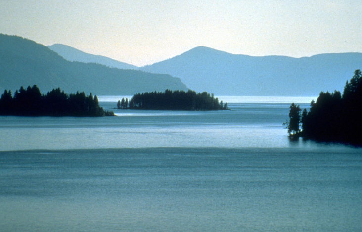
EPA has been using this test for quite some time now and has an extensive guidance document for field personnel to use in deciding whether a wetland meets the criteria for “significant nexus”.  They came upon a bit of difficulty with implementing this test though when they issued Mr. and Mrs. Sackett of Priest Lake, Idaho a violation for infilling wetlands on property where they were trying to build a home. The Sacketts sued. The Sacketts property is located across the street from a ditch that leads into a creek which eventually feeds into Priest Lake, a navigable intrastate lake that is considered a WOTUS.  The EPA’s contention was that the wetlands on the Sackett’s property were similarly situated with the Kalispell Bay Fen wetland nearby and therefore constituted WOTUS.

The Ninth District Court ordered summary judgment for the EPA in the lawsuit saying that “the CWA covers wetlands with an ecologically significant nexus to traditional navigable waters and the Sackett’s wetland satisfied the standard.”

The case was appealed by the Sacketts and arrived last year (nearly 20 years after they bought their land on Priest Lake), to be argued in front of the Supreme Court. All nine Supreme Court justices ruled in favor of the Sacketts, saying their property did not meet the definition provided in the CWA for being considered “adjacent wetlands” and that EPA’s “significant nexus” test is not covered by the CWA.

This ruling must be a huge blow to the Office of Water at EPA and fill its corridors with woe. A lot of time has been taken up over the last 12 years writing and rewriting regulations. Now their latest rule on definition of WOTUS has been thrown out by the Supreme Court and regulatory jurisdiction over many traditionally regulated wetlands has been called into question.  Lots of people warned them about this potential outcome when they proposed writing regulations on WOTUS back during the Obama Administration. Now it has all come to fruition.

Waters of the United States 2023 Rendition

Albert Einstein once said that the definition of insanity is doing the same thing over and over again and expecting different results. In the last eight years there have been three rewrites of the definition of the Waters of the United States (WOTUS) under the Clean Water Act (CWA) by the U.S. Environmental Protection Agency (EPA) and its co-regulator The Department of the Army who administers part of the law through the U.S. Corps of Engineer (Corps.) For some history on the subject seek out my blog post at this link ( Environmental Protection Agency Announces Clean Water Act Rule.)

            The first rewrite was in 2015 and it was termed the “Clean Water Rule” but should have been titled the “Clear as Mud Rule” (see  Environmental Protection Agency Announces Clean Water Act Rule .) This was replaced in 2020 by the “Navigable Water Protection Rule” which should have been titled “The Do Anything You Want Rule” (see Waters of the United States  .) Now we have the new 2023 “Revised Definition of the Waters of the United States.” You could call this insanity or use my word for it – silly. The pre 1985 regulations were working just fine until in 2006 the Supreme Court – well known as an august scientific body – stepped in with a criticism of the process. Their beef was that they kept getting cases challenging the decision of the Corps on administration of the part of the law they are responsible for – the CWA 404 (d) rules regulating the disposal of materials into waters of the U.S. including wetlands.

            There is a long history of disputes through the court system on application of the CWA regulations and sometimes they reach the Supreme Court. This is what happens when you have a poorly written law, however no one wants to rewrite the CWA as these days that might result in wholesale slaughter of the Act or, so I was told a few years ago by senior officials at the Department of Justice. So now we get these silly continuous rewrites of the regulations.

            The 2023 rendition started out well as it purported to go back to the original 1985 regulations, but then the regulators decided wouldn’t it be just dandy if we include two different tests to determine if nearby wetlands or upstream tributaries to traditional (a)(1) WOTUS are WOTUS too.

The definition of (a)(1) waters is straight from the CWA:

Waters of the United States

(a) Waters which are:

            (i) Currently used, or were used in the past, or may be susceptible to use in interstate or             foreign commerce, including all waters which are subject to the ebb and flow of the tide;

            (ii) The territorial seas; or

            (iii) Interstate waters, including interstate wetlands

The two tests included in the new regulations are:

  1. the “relatively permanent standard,” and
  2. the “significant nexus” standard (which has been informally used for a number of years after a 2006 Supreme Court decision in which Chief Justice Kennedy wrote that this was the test an adjoining water body should pass to be considered a WOTUS.)

            The “relatively permanent standard” is a fairly understandable test whereby a wetland or upstream tributary will be considered a WOTUS if it is: “a relatively permanent, standing or continuously flowing waters connected to (a)(1) waters and waters with a continuous surface connection to relatively permanent waters.”       

            But what in the world is a significant nexus? The new rule defines it as tributaries or wetlands that “either alone or in combination with similarly situated waters in the region, significantly affect the chemical, physical, or biological integrity of waters identified in paragraph (a)(1) of this section.”

            This means if you want to develop a property within a tributary or wetland in a wide vicinity of one of these (a)(1) waters then CWA regulators must decide if the water on your property is affecting them. If the wetlands or small steams from your property are filtrating or reducing sediment, contaminants of other sorts, or harmful biological matter from the (a)(1) waters than you’re likely not going to be able to develop there. Or say the waters on your property provide for the extant water sources of (a)(1) water that support biological resources such as fish and the chain of biological organisms they feed on then you’re not going to be able to develop there either.

            Welcome to the water wars. They’ve been going on for over a hundred years in the U.S.  The wars are just getting larger due to increased population growth and consequent development. The current rewrite of the definition of WOTUS will do nothing to solve the legal challenges. It throws the problem back again on the regulators to make the decision of whether a particular property is a WOTUS or not, just as it always has been.

            There is already a challenge to the “significant nexus” standard as defined in the new regulation. The case of Sackett vs. the EPA was taken up by the Supreme Court in late 2022. In brief this is an old dispute dating back to 2007 where a property owner was attempting to infill a wetland for development and was stopped by the EPA for violating the CWA. That’s why I started this blog post with the definition of insanity. Depending on the Supreme Court decision, we may yet see another rewrite of the WOTUS regulations. You can probably tell by the tone of this blog post that I’m getting fed up with the whole issue but I’ll continue to update my readers on this ongoing silly saga.

Definition of the Waters of the United States: Version 3.0

Here we go again. Possibly the most frustrating and boring occupation on the face of the earth is being a regulation writer for the U.S. Environmental Protection Agency (EPA). These poor suckers can spend an entire career writing and rewriting the same regulation. I don’t know what sad soul is stuck with yet again rewriting the regulation for the definition of the Waters of the United States but if I were them I’d start looking for another job, because this won’t be the last time. This regulation is way beyond controversial. For a synopsis of the history of the regulation check out my 2018 post here.

On June 9, 2021 the EPA and the Department of the Army (under which resides the Army Corps of Engineers (ACOE or Corp) that administer the Clean Water Act 404(d) permit program) once again announced their intention to revise the definition of the Waters of the United States (WOTUS.) In 2020, the Trump administration revised a 2015 Obama era WOTUS regulation, so the Biden Administration has decided that it needs to revise the regulation too, because just too many projects impacting ephemeral streams and ditches are moving forward. Ephemeral streams being those that only flow briefly during and after localized rainfall. Ditches are simply man-made structures carrying runoff. Ephemeral streams and upland ditches were exempted from regulation in the 2020 version of the rule. The EPA was sued in 2021 by the Pueblos of Laguna and Jemez in New Mexico because just about every contributing stream to their water supply is ephemeral. It is very dry in their part of New Mexico and they have valid concerns about projects off reservation that might be impacting their water supply. The pueblos want ephemeral streams to be redesignated as WOTUS for protection of the waters they use for domestic and agricultural purposes. There’s a bunch of other lawsuits too from an assortment of state governments, including New Mexico, and from the Conservation Law Foundation and other environmental groups. This is all standard procedure now after a regulation is issued. There were lawsuits after the 2015 regulations were issued as well.

            This is really all about the Clean Water Act 404 (d) program. The EPA is responsible for revising regulations under the CWA but the ACOE is charged with administering section 404 (d) of the CWA and issuing permits for any construction or dredging in areas that are considered WOTUS. The ACOE supported the EPA’s intention to revise WOTUS by assessing how the 2020 regulations have impacted their permitting program. They filed a Memorandum for the Record on June 8, 2021 with 165 pages of supporting documentation of their analysis.

            Here’s a little bit of background for you so you can understand their analysis. Before a member of the public submits a permit application, they can seek a determination of whether their project is actually within a WOTUS and receive what is called a jurisdictional determination.  There are two types of determinations: 1) approved jurisdictional determinations and 2) preliminary jurisdictional determinations.

            An approved jurisdictional determination is an actual official document giving the ACOE’s view of whether WOTUS exist within a project area. A preliminary jurisdictional determination allows an applicant to waive the jurisdictional decision-making process of the ACOE and go right to the permit decision. In the case of a preliminary jurisdictional determination, the ACOE is not making any determination of whether a WOTUS exists in a project area and they issue a general or individual permit based on the permit application. In other words, the project proponent is assuming there’s WOTUS within their project area when seeking a preliminary jurisdictional determination. It’s not at all necessary for a project proponent to request a jurisdictional determination in cases where the project isn’t regulated under the CWA or is exempt and indeed the ACOE issues many general permits that have no jurisdictional determination. I know this may sound like your typical government bureaucratic bullshit, but it’s how the Corp does things and they keep track of it. So as part of their analysis of how the 2020 regulations were impacting their permitting process, the ACOE checked how many approved jurisdictional determinations they’d made versus preliminary jurisdictional determinations then compared them to the numbers issued under the Obama regulations and the pre-Obama regulations. 

            Here’s what the ACOE found:

            1) Under the 2020 regulations 71 percent of approved jurisdictional determinations found there were no WOTUS within the project area. Under the 2015 regulations 46 percent of these types of determinations found no WOTUS within a project area. Most of the waters being assessed and not meeting WOTUS criteria were ephemeral streams or wetlands excluded under the new adjacency requirements in the 2020 regulations. Ditches were a smaller percentage of water resources not determined to be WOTUS. 

            2) Since the 2020 regulations became effective the number of approved jurisdictional determination requests has gone up by 116 %, meaning that permit applicants are no longer assuming that WOTUS exists within their project area.

            3) Based solely on examination of approved jurisdicational determinations, the number of permits required to be issued has greatly decreased compared to the numbers issued prior to 2020. There were 338% more permits issued under the Obama regulations and 412% more under the pre-Obama regulations.

            As you can see the 2020 regulations have had some big impacts and they are obviously not ones that the new Administration is comfortable with maintaining.             I will be following, as I’ve done in the past, the writing of the new regulations, so look for future updates in this blog.  

Repeal of the Clean Water Rule

The Administrator of the U.S. Environmental Protection Agency (EPA) and the Assistant Secretary of Civil Works for the U.S. Army (essentially the Corps of Engineers since they implement portions of the Clean Water Act) signed a “Recodification of a Pre-existing Rule” on September 12, 2019.  According to the summary in the text, the Recodification “repeals” the Clean Water Rule of 2015.  I have written multiple times in this blog on the complicated regulatory and legal issues surrounding the Clean Water Rule of 2015.   For background check out these links: https://waterblogger.org/water-quantity/waters-of-the-united-states/

          The item being recodified is the definition of the “Waters of the United States” (WOTUS) under the Clean Water Act (CWA), or in simpler terms, what bodies of water are regulated under the Clean Water Act.  In a nutshell the Clean Water Rule of 2015 was seen by many states as a water grab by the federal government, because states have traditionally managed waters within their boundaries and the new definition expanded the water bodies covered by the CWA.

          However the definition of WOTUS which existed prior to the Clean Water Rule of 2015 was difficult to implement and a number of regulatory decisions made by federal agencies to include wetlands and water bodies adjacent to tributaries as WOTUS were appealed by landowners through the court system.  A couple of these cases reached the Supreme Court.  The Supreme Court directed the federal agencies to provide a resolution as to what bodies of water were WOTUS.  As a result the EPA rewrote the regulations and used a science based approach to do so.  The new regulations published in 2015 were dubbed The Clean Water Rule. 

          These rewritten regulations were a spectacular failure and since 2015 there has been an ocean of litigation.  Lawsuits were brought against the Clean Water Rule by a group of 28 states.  This litigation resulted in judgments that stopped implementation of the Rule in those states.  Those 28 states have been operating under the original regulations ever since.  The other 22 states have been operating under the new 2015 Clean Water regulations. 

          The purpose of the Recodification is to reinstate the original regulations which existed before the 2015 Clean Water Rule was implemented.  With the Recodification all 50 states will be operating under the original regulations – at least until whatever new litigation gets underway.  The Recodification text gives four reasons that support the repeal.

          First, a Supreme Court decision dictated that the EPA and the Corps of Engineers needed to define the limits of their authority to implement the CWA.   The 2015 Clean Water Rule failed to do so.  (A lot of states envisioned that the lack of a limitation could lead to every drop of water in the U.S. being subject to the CWA.)

          Second, the 2015 Clean Water Rule didn’t recognize, preserve, and protect the primary responsibility and rights of the states to manage their own land and resources.  (The western states and the big agricultural states jealously guard their right to manage water within their state boundaries so the Clean Water Rule, by expanding the federal government’s regulatory authority over water bodies, really riled them up.)

          Third, without any authorization from Congress the 2015 Clean Water Rule provided a regulatory framework that could have led to encroachment on the state’s land use planning authority.   (States were concerned about traditional state and local authority over land use activities like conversion of land for agricultural and other uses.)

          Lastly, the 2015 Clean Water Rule’s attempt to define the scope of a tributary or adjacent waters inclusion under the CWA resulted in some procedural errors and lacked adequate record support.  (Basically a couple of court cases said EPA didn’t meet the arbitrary and capricious standard under the Administrative Procedures Act.  It looked like the agency while writing the final regulations had just pulled a bunch of numbers out of a hat to define the distance a tributary or adjacent water had to be from a WOTUS to be included as a regulated water body.)

          The Recodification has not yet been published in the Federal Register so it is not yet being implemented.  It is also being called “Step 1.”  After the Recodification, “Step 2” will be implemented.  “Step 2” just happens to be a new Rule defining WOTUS.  This new rule published for comment in 2018 tries to simplify the definition of a “WOTUS” by making it a legal definition instead of a definition based on science.  A description of this new Rule can be found at this link: https://waterblogger.org/general-information/revised-rule-on-the-definition-of-waters-of-the-united-states/

          Stay tuned.  I’ll keep you up to date as the regulation winds its way through further trials and tribulations. 

Waters of the United States

Warning: This is not a science post.

On December 11, 2018, the U.S. Environmental Protection Agency (EPA) and the U.S. Army Corps of Engineers made available their proposed rewrite of the 2015 “Clean Water Act Rule.” This revised rule will be posted in the Federal Register, however the EPA has already made it available on their website for advance review. The new revised Rule is entitled simply “Waters of the United States (WOTUS) Definition”, which is what this Rule was about from the beginning. I always thought that the previous title of “Clean Water Act Rule” was simply a ruse to confuse people about the intention of its contents.

The Clean Water Act (CWA) applies to “navigable waters of the United States.” The definition of what is a “navigable water of the United States” prior to 2015 was so obtuse that enforcement often ended up in litigation. Several of these cases have made their way to the Supreme Court for resolution.

EPA’s rewrite of the Rule in 2015 was supposed to clear up the inconsistencies in the application of the regulations. EPA’s idea at the time was to use science to define a “WOTUS.” The Agency conducted a science review of the physical, chemical and biologic connections between water bodies and used the resulting report in providing a definition. The problem is that the natural world is a messy sort of place where pretty much everything connects with everything else. The natural world does not fall into a neatly laid out legal scheme such as the Clean Water Act. So the 2015 Rule encompassed almost every drop of water in the United States into the definition of a “WOTUS.”

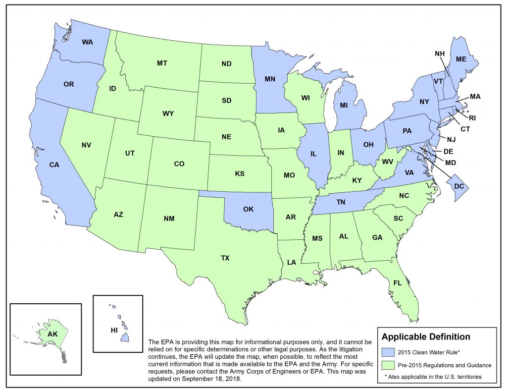
Back in 2015, I posted quite a bit on the “Clean Water Rule” (check out this link to read past posts https://waterblogger.org/water-quantity/a-review-of-the-environmental-protection-agencys-connectivity-of-streams-and-wetlands-to-downstream-waters-post-1/) and I have been following the subsequent litigation over that Rule. I would put the 2015 rule making process in the category of one of the most disastrous examples of federal regulatory efforts ever. It has resulted in a patchwork of 22 states across the country where the 2015 “Clean Water Rule” is in effect, while the rest of the states are still using pre-2015 regulations and guidance of what constitutes a WOTUS. This is because the chief plaintiffs in the lawsuits against EPA were the other 28 states. These states consider waters within their boundaries as mostly state waters to be managed by them. A federal court set aside implementation of the regulations in the states that sued until litigation was complete. Below is a map taken from EPA’s website that shows where the two different regulations are in effect.

The revised 2018 Rule tries to simplify the definition of a “WOTUS” by making it a legal definition instead of a definition based on science.  Hence my warning above saying there is no science in this post. The preamble to the 2018 Rule says it best and I quote: “The line between Federal and State waters is a legal distinction, not a scientific one, that reflects the overall framework and construct of the Clean Water Act.”    

In brief EPA has defined “WOTUS” to be: “traditional navigable waters, including the territorial seas; tributaries that contribute perennial or intermittent flow to such waters; certain ditches; certain lakes and ponds; impoundments of otherwise jurisdictional waters; and wetlands adjacent to other jurisdictional waters.”

The new revised Rule does not include ephemeral tributaries which flow only as a result of precipitation. This is a major change from the 2015 Rule. The 2015 Rule considers all tributaries, including ephemeral ones, as WOTUS if they contribute flow directly or through another water body to a WOTUS and have the physical indicators of a bed and banks and an ordinary high water mark. I consider this the make work for hydrologists provision of the 2015 Rule. Each decision would have to be made by a hydrologist. In the case of ephemeral streams, it could result in an argument between any two reasonable hydrologists as to the above mentioned physical indicators. It could all end up back in court again.

In fact much of the 2015 Rule relies on case specific analysis of a particular water to determine if there is a clear connection to another water which is a “WOTUS.” The writers of the 2018 Rule have taken the stance that anyone should be able to identify what a “WOTUS” is from the regulation. The 2015 Rule was 9 pages. The 2018 Rule is 60 pages. I suppose this is in hopes that a farmer or developer can take all those extra pages with them and stand next to their ditch or wetland and see if it fits within the definition. I joke of course. Most of the extra pages are just references to sections of various laws which need to be amended with the new definitions. The Rule does little to help your average non-scientist or non-lawyer to clearly differentiate between what is covered and what isn’t.

There are some definitions which could help the average Joe in determining if they have a WOTUS. For example, ditches constructed in uplands are not regulated under the 2018 scheme. This is a major victory for the farmers as they are the ones who probably have the most ditches on their property and who were some of the people most upset by the 2015 “Clean Water Rule”. Upland is defined as any land area above the high water mark or high tide line that doesn’t satisfy wetland criteria of having wetland hydrology, hydrophytic vegetation (plants that live in submerged conditions), and hydric soil (saturated soil) under normal conditions. Unless it’s a ditch like the Erie Canal that you can navigate, a ditch altering a tributary or built in an adjacent wetland to a WOTUS then you can be pretty confident that you are not going to have to get a federal permit under this new Rule.

There’s also a fairly sharp line drawn for what lakes and ponds qualify as a WOTUS. A lake and pond has to have a clear surface water connection to a WOTUS or be flooded by a WOTUS during a typical year for them to be considered as regulated under the CWA.  Isolated ponds even though they might have some hydrologic connection via groundwater to a WOTUS are excluded.   

What is surprising and to me not clear at all is the application of the 2018 Rule to wetlands. The only wetlands to be considered WOTUS are those that are adjacent to waters regulated under the new 2018 Rule. Adjacent means the wetland must abut a WOTUS. Abut in the regulations is defined as where a wetland actually touches a WOTUS at either a point or a side. The wetland also must have a direct surface connection to the WOTUS. No subsurface groundwater connections allowed. Any wetland that is physically separated from a WOTUS by upland, or by dikes, barriers or similar structures is not regulated. The preamble says that this will end the need to make case specific evaluations of wetlands to determine if they have a hydrologic connection to a WOTUS.

I doubt it. This is going to be far more difficult than the writers of this Rule imagine. Property owners will neither be able to make the determination themselves that there is a direct surface connection which occurs either from a wetland being inundated by a regulated water such as a tributary, lake, pond/impoundment, or ditch, nor in many cases are they going to be able figure out if there is surface flow from the wetland to the regulated water. No that is going to take a professional determination.

There are a number of other exclusions to the application of the Rule specified in the text including groundwater, prior converted cropland, artificially irrigated areas for rice and the like, stock ponds, settling basins, log cleaning ponds, water filled depressions as part of a mining or construction, gravel and fill pits, storm water ponds and waste water treatment systems. I suspect once the Federal Notice comes out there will be quite a few comments made to the public record and we will see another rewrite, but it is unlikely in my opinion that we will see anything that can satisfy the EPA Administrator’s desire for a set of regulations whereby the average person will be able to make a determination of whether a water body is a WOTUS. Trying to regulate natural hydrologic systems is about as clear as the mud in a wetland.        

Revised Rule on the Definition of “Waters of the United States”

On December 11, 2018 the Acting U.S. Environmental Protection Agency (EPA) Administrator Andrew Wheeler held a live video announcement about the upcoming release of the revised regulatory rule on the definition of the “Waters of the United States” – also referred to by some as the Clean Water Rule. According to Wheeler, the rule will be advertised in the Federal Register within the next four weeks but will also be posted in advance on the EPA website. Once the Rule is advertised in the Federal Register, there will be a 60 day public comment period. Wheeler stated during the question and answer session of the video announcement: “the rule will allow you to stand on your own property and tell whether it is a water body under Federal jurisdiction.”  

Dams and their Impacts on Wetlands

In my post on the Clean Water Rule and floodplain wetlands, I mentioned floodplain wetlands had been reduced so much after hurricane Katrina that scientists were concerned about the increased risk of flooding from future storms. I didn’t have time while I was writing the post to do a fact check on how much of the wetlands in Louisiana had been impacted, but I decided to follow-up just for my own information. I sat through a presentation by U.S. Geological Survey scientists twice on this subject, so I went looking to see if I could find the information on their website. I was amazed to find the very PowerPoint presentation I’d seen some eight years ago now.  It was produced by the Geological Survey’s Wetlands Research Center and the Louisiana Coastal Area Land Change Study Group. It provides a close look at land loss after the hurricane in comparison to land loss before the hurricane. They used satellite images to make their determination. I also found their final report on the subject: “Land Area Changes in Coastal Louisiana after Hurricanes Katrina and Rita.” (Here’s a link:http://pubs.usgs.gov/circ/1306/pdf/c1306_ch5_b.pdf). Bet you forgot about Rita, but yes there were two very destructive hurricanes affecting the Gulf Coast in 2005. The final report put the loss of wetlands from the two storms at a total of 217 square miles.


That sounds like a lot doesn’t it? But the reports from the Geological Survey put wetland loss from 1956 to 1978 in Louisiana at about 40 square miles a year. That’s an 880 square mile loss over 22 years. The Geological Survey also reports an approximately 35 square mile loss of wetlands per year from 1978 to 1990 for a 12 year loss of 420 square miles. Of course all these losses took years not hours to occur, but what is the reason for such incredible losses of wetlands?


People who are familiar with Louisiana and the great Mississippi River know the answer to that question. The Mississippi River isn’t really a river any more. It’s just a channel conducting water. The same goes for its major tributaries: the Missouri River, the Arkansas River, the Ohio River, and so on. Yes the mighty Mississippi, storied in American history and literature, is an over engineered navigational conduit to get goods from North to South and a pesky source of flooding to landowners along its length. The start of all the troubles began early, even before Mark Twain’s time as a steamboat captain. The steamboats went aground all the time in big piles of snagged trees in the middle of the river and on sandbars. So engineers devised ways to remove those snags and dredge the sand. But the real change for the Mississippi came after the flood of 1927, which was the beginning of the end for the free flowing great water body. I went back to the Army Corps of Engineers documents and also looked around at some of the National Research Council’s reports, but the best document I found on the channelization of the Mississippi came from a compilation report produced by the Geological Survey back in 2012. It is titled: “A Brief History and Summary of the Effects of River Engineering and Dams on the Mississippi River System and Delta.” (Here’s a link to the report: http://http://pubs.usgs.gov/circ/1375/C1375.pdf).  I like the Geological Survey’s reports. They are always well written, not like the mumbo jumbo you get out of some federal science agencies.


The report says that in 1927 about 43,500 square miles of land in 7 states was flooded and 246 people were killed. The flood of 1927 was kind of a legendary flood but most people today have never heard of it. All sorts of historic events are claimed to be a result of the flood, including the great migration of displaced African Americans from the Mississippi delta to northern cities and the election of Herbert Hoover as president of the United States based on his oversight of the flood relief efforts. (Presidents Hoover and Carter are the only engineers ever elected president). Basically a plan was implemented starting in 1929 to straighten out this flooding problem. And I do mean straighten out. Rivers are big complex bodies of water. They don’t have one channel, they have multiple channels. They meander over their floodplain. The basic mechanism creating meanders is high velocity water undercutting a river bank then depositing the sediment downstream on a bank on the other side of the river where the velocity of the water is lower. A program of cutoffs was instituted to reduce the number of channels and to cutoff large meanders. This program literally shortened the river. The lower Mississippi river lost some 145 miles as a result of this program. Then revetments were added to the banks of the Mississippi. Don’t know what a revetment is? They are essentially concrete mats that cover the entire bank of a river all the way to where it joins the submerged river bed.  Rip rap is also used. Back when the engineers were first seeking to control the river, they used a lot of rock and matting. The idea is to stop bank erosion and keep the river from migrating.


There were already levees before the time of the 1927 flood. Now there are miles of levees. You probably remember seeing them on television during the Katrina hurricane coverage. They are tall, wide compacted, earthen dam like structures that parallel a river. The Geological Survey says there are 3500 miles of levees just in the lower part of the Mississippi River Basin. There are levees everywhere in Louisiana on the banks of the Mississippi. In New Orleans you can stand on the ground in some areas and see the levees towering overhead with the river at the crest of the levee and a cargo boat steaming by above you. The levees are there to keep the river from flowing into its’ floodplain when water in the river is high. They also starve the floodplain of sediment and nutrients.


The other types of engineering control you’ll find on the Mississippi River are floodways and dikes. You’ll see floodways in New Orleans and other towns on the Mississippi River. They are there to redirect flood waters from the river away from a city into an area that is not quite as populated. They are big structures and the lower Mississippi in Louisiana has three really large ones. Dikes are just like the dikes you see sticking out into the ocean when you go to the beach, but on rivers they are usually protruding at an angle from the river bank. The purpose of the dikes is to direct the strong currents away from the bank to prevent erosion and meandering. What results is a strong current right down the middle of the river which scours out the river bed sediments and actually makes the river deeper.


One thing you won’t see on the Mississippi River thank goodness is a dam, at least in the lower part of the river. The upper Mississippi has a series of navigational locks and dams starting around Minneapolis that extend down to the Missouri River. All the main tributaries to the Mississippi have dams though. The Missouri river has six big ones. The Missouri River is essentially a system of reservoirs interspersed with channels. Again the dams provide flood control, but the big thing they prevent is sediment moving down into the Mississippi River. The Geological Survey says that the dams on the Missouri River have resulted in an enormous amount of sediment from reaching the Mississippi River and subsequently the floodplain wetlands in Louisiana. I didn’t realize that the Missouri River was the greatest contributor of sediment to the Mississippi from any of its tributaries. The Missouri drains the Great Plains and includes flow from the Arkansas and Red River Basins. Due to the semi-arid environment and lack of vegetative cover to stabilize soils, there is a lot of erosion. You would think with the dry climate there wouldn’t be a lot of transport of the sediment, but apparently rains during the fall are sufficient to wash those sediments into the Mississippi. Or at least that’s what used to happen. Now with all those dams, the sediment is just sitting there filling up the reservoir behind the dam and starving the downstream wetlands.


The Geological Survey report says that only about 40 % of the sediment that used to be transported by the Mississippi River makes its way to the Louisiana coast now. No wonder there is such a big loss of wetlands. Add in all those levees in south Louisiana preventing the river from connecting with the floodplain wetlands and you get essentially what I would call an ecological disaster in the making. Here’s something even worse though, although the Missouri River provides the lion share of sediment to the Mississippi River, it only contributes about 12 percent of the water. Half of the water going into the Mississippi comes from the Ohio River. Well of course, there is a lot more rain in Ohio, Illinois, Indiana, Kentucky, Pennsylvania and West Virginia through which the Ohio River flows than the states through which the poor old Missouri River flows (Montana, South and North Dakota, Nebraska, Kansas and Missouri).  But you know what exists along the Ohio River – lots of farms with soybeans and corn and lots of farms with cows and pigs and other animals. What with all the fertilizer and manure runoff, the Ohio is the largest contributor of nitrogen to the Mississippi River. If you have been reading my posts on the Clean Water Rule, you will know that wetlands are a great means of removing nitrogen from water. You disconnect the river from the floodplain and wetlands and all that nitrogen goes down and empties into the Gulf of Mexico. What happens next is famous – the Gulf of Mexico dead zone. All this nitrogen pouring into the Gulf results in a massive growth of phytoplankton which depletes the oxygen in the water and results in fish kills. The Geological Survey report said that in 2002 the dead zone in the Gulf of Mexico was as large as the state of Massachusetts.


So there you have the result of a river not being a river anymore. Dams exist on so many of our major rivers and have forever altered the landscapes downstream. I will be looking at the scientific literature on dams over the next few months and writing about the impacts to water quality and morphology of landforms.

Clean Water Rule: A Review of the Environmental Protection Agency’s “Connectivity of Streams and Wetlands to Downstream Waters” Post 4 – Non-Floodplain Wetlands

I am a big hiker. I love to hike and I have hiked all over the United States and much of the world. There is nothing better than taking off with your backpack and a tent and spending days on the trail enjoying nature. It has given me an opportunity to get a close look at many different watersheds and wetlands. One of my husband’s favorite stories about me took place while we were hiking the Coast to Coast trail in northern England. We were picking our way up a hill through a bog, when I stepped on a patch of the bog that was not solid enough to handle my weight and I sank down to my waist. He had to pull me out all dripping wet and dirty. Vertical bog? Yes, it rains constantly in some areas. I have some cities on my smart phone weather app that no matter when I look at them, it is raining there. Maybe it’s not a hard rain, but it just rains and rains. If you want to hike in northern England and Scotland get yourself a good rain suit. You will need it.  In these areas the water may runoff a little bit, but much of it just soaks into the soil and vegetative mass and forms bogs. Bogs are non-floodplain wetlands.


Other types of non-floodplain wetlands are also on hillsides. They are called slope wetlands by some people, but I’ve always known them as seeps. I see them when I’m hiking in the mountains all the time. Mostly they are small but I have seen some pretty large ones too. Just this spring I walked over boards through a seep wetland. I must have hiked about a quarter of a mile on those boards. Seeps are groundwater fed and are usually found at slope breaks, at the contact of two geological formations, or where the water table is really high.


I’ve also worked in many remote areas of the United States and around the world. I worked in South and North Dakota for awhile. While I was there I got an opportunity to drive through some of the prairie pothole areas in North Dakota and get out and take a look. It is a fascinating continental glacial terrain. Apparently those continental glaciers were huge. In places geologist estimate continental glaciers were several miles thick. That’s a lot of ice. And a lot is going on with those continental glaciers. They move, although very slowly. They are grinding up the countryside underneath them and pushing it in front of them. They have channels of water running through them and on top of them. They spread out and then retreat leaving frozen blocks of ice behind in unsorted glacial silt, sand and gravel. The continental glaciers that covered large parts of the northern mid-west left an interesting terrain. There are broad mounds of glacial gumbo called moraines that run for miles. There are long sinuous ridges of well sorted glacial sands and gravels called eskers. There are symmetric and asymmetric depressions containing water called kettles. And the whole area is covered by several hundred feet of poorly draining glacial till. Many of these glacial terrains are characterized by non-floodplain wetlands, including what are called prairie potholes.


There are a lot of different kinds of non floodplain wetlands and EPA describes them in laborious detail in their report “Connectivity of Streams and Wetlands to Downstream Waters.” They describe non-floodplain wetlands which are simply topographic depressions and may or may not have surface water inlets or outlets, such as: kettles, potholes, vernal pools, playa lakes and Carolina bays. They describe a host of slope or seep wetlands including something called a fen. I actually had to look this one up in the dictionary. Fens are kind of like bogs but not as acidic so they support a lot of diverse vegetation. And further, EPA describes mineral soil flat wetlands which include relic lake bottoms, peat bogs, and the like. In other words there are a ton of different kinds of non-floodplain wetlands.


In my last post I discussed the findings of the Environmental Protection Agency’s (EPA) scientific assessment of the connection of floodplain wetlands to downstream waters. Today’s post looks at the connection between non-floodplain wetlands and downstream waters. This is the fourth in a series of posts which review the EPA’s report: “Connectivity of Streams and Wetlands to Downstream Waters.” EPA’s report is an assessment of the scientific literature published in peer review journals which present research on interactions within watersheds that affect “waters of the United States.” The report is the scientific support for the Clean Water Rule. If you have read the other posts in this series, you will know the Clean Water Rule, which was issued in the summer of 2015, defines “waters of the United States” under the Clean Water Act. The Clean Water Act allows regulation of the “waters of the United States” but never wholly defines it. As a result there have been various interpretations by regulators on what is covered as “waters of the United States”, which in turn have caused a lot of surprise for a few people who have filled in wetland areas and then received federal violations under the Clean Water Act.  Some of these surprises have ended up in the legal system and a few over the years have wound their way up to the Supreme Court. The Court has not been in the mood to define “waters of the United States” and why should they? It is really not their job. So EPA who has the responsibility for writing regulation and rules under the Clean Water Act took on the challenge.


EPA’s report “Connectivity of Streams and Wetlands to Downstream Waters” looks at the physical, chemical and biological connection of streams, floodplain wetlands and non-floodplain wetlands to determine if there is a “significant nexus” to downstream waters of the United States. “Significant nexus” are the words the Supreme Court used to tell EPA a connection must be established between wetlands and a river if wetlands are to be regulated as waters of the United States under the Clean Water Act. Establishing a clear connection between the hugely different and diverse types of non-floodplain wetlands to downstream waters using the scientific literature was probably EPA’s Waterloo for the Clean Water Rule. As the report describes it, in the case of non-floodplain wetlands, there can be a range of connectivity. The connection can be permanent, but it can also be occasional or rare. The connection can be by channels intersecting the wetlands and downstream waters or through groundwater flow. Sometimes the wetlands are connected to downstream waters only through connection to other wetlands. And sometimes non-floodplain wetlands are completely isolated and have no connection to downstream waters.


But where there are connections, even when the connection is only occasional or rare, the connection can have a significant impact to downstream waters. EPA cited one study in Maine that showed non-floodplain seep wetlands were providing 40 to 80 percent of baseflow in downstream waters. Another study EPA cites is on vernal pools in California. Vernal pools are usually dry; they only fill up during heavy rain months or when there is a lot of snowmelt. The study showed that water from the pools spilled into downstream channels 60 percent of the time water filled the vernal pools. A study of Carolina bays showed there were intermittent seasonal surface water connections to streams when water tables were high in the spring and fall. A study of depressional wetlands on the Texas Gulf coast showed there were connections to downstream waterways through surface runoff. There’s even a study showing prairie potholes can be connected temporarily to other potholes through surface water flow during really wet years.


Similar to floodplain wetlands, non-floodplain wetlands help reduce flooding in downstream rivers and streams. Surface flow from snowmelt or large rain events is caught and “stored” by non-floodplain wetlands, but not in all cases. EPA cites several studies where non-floodplain wetlands in permafrost areas and seep wetlands provide no storage of water. And even where non-floodplain wetlands are directly connected to downstream waters if the wetland is already saturated, then there is no ability for it to retain further moisture and reduce downstream flooding.


And just like floodplain wetlands, non-floodplain wetlands have the ability to remove and transform nitrogen and phosphorus. Even if the non-floodplain wetland is not connected to downstream waters, the vegetation in wetlands are busy slurping up nutrients for growth and energy, micro flora and fauna are breaking down organic material, and sediment from surrounding areas is piling up. If the non-floodplain wetland is connected to downstream waters than all the same benefits provided by floodplain wetlands in reducing nitrogen and phosphorous runoff into streams and rivers applies. If the non-floodplain wetland isn’t connected to downstream rivers and streams, well guess what, the benefit is still there. Non-floodplain wetlands are reducing overland run-off, full of nitrogen and phosphorous, which would eventually end up in rivers and stream. EPA cited one very interesting study that found some depressional wetlands absorbed two times as much phosphorous as floodplain wetlands.


And what are the bugs and frogs up to? All sorts of flying insects that you find in floodplain wetlands are breeding in the non-floodplain wetlands too: mayflies, caddisflies, diving beetles, backswimmers, whirligig beetles, waterstriders, waterboatmen, crane flies and midges. If you are a fly fisherman you probably know these bugs. So unconnected wetlands are still providing food for fish. EPA says the use of frogs of non-floodplain wetlands and their connection to populations of frogs downstream is well documented in the scientific literature. Also apparently is the connection for alligators. I guess if you fly or hop or crawl or walk, you don’t have to worry about a triviality like running water.


In the end EPA made some observations based on their findings about non-floodplain wetlands and I would like to quote them but in the interest of brevity, for which most scientists are not famous, I’m going to summarize it. Basically non-floodplain wetlands (as we’ve seen in this post) are extremely diverse and even if you think a wetland is isolated it might not be (just because it looks that way on a map or satellite image doesn’t mean it is isolated if data quality of the image isn’t good or if the view is obscured by vegetation); and some non-floodplain wetland complexes could have a connection to downstream waters through channels even if individual non floodplain wetlands within the complex are isolated. So to wrap it up, EPA kind of said: it’s complicated.


And unfortunately it is complicated. In college I was taught about the hydrosphere and the hydrologic cycle. Water precipitates from the sky, it falls on the ground, and it runs off into wetlands, streams and rivers which in turn run into the ocean. Or rainwater soaks into the earth and becomes groundwater which is stored in an aquifer or moves slowly through the rock and discharges into a seep or a stream or a river. Water evaporates from wetlands, streams, rivers and oceans and form clouds. Then it starts all over again as it rains once more. So loosely, you might say every drop of water connects with every other drop of water in some way. Trying to disconnect all that water through defining the “waters of the United States” is obviously a challenge.


Just an update for those of you who have been following the legal battle on the Clean Water Rule. Last week on October 9, 2015, the Sixth Circuit Court of Appeals in Cincinnati, Ohio issued a nationwide stay in the implementation of the Clean Water Rule. You may remember the Clean Water Rule was effective back on August 28, 2015 and that a North Dakota Court similarly blocked implementation of the Rule almost immediately afterward. This earlier injunction was only applied to the 13 states that were plaintiffs in that case. So 18 other states petitioned the Sixth Circuit Court of Appeals to block implementation of the Clean Water Rule nationwide while challenges to the Rule wind their way through the legal system. I read the Sixth Court’s decision and was particularly pleased to see the following statement which acknowledges the science and expertise EPA brought to the task of writing the Clean Water Rule:


“Given that the definitions of “navigable waters” and “waters of the United States” have been clouded by uncertainty, in spite of (or exacerbated by) a series of Supreme Court decisions over the last thirty years, we appreciate the need for the new Rule. See Rapanos, 547 U.S. 715; Solid Waste Agency of N. Cook Cty. v. U.S. Army Corps of  Engineers, 531 U.S. 159 (2001); United States v. Riverside Bayview Homes, Inc., 474 U.S. 121(1985). In one sense, the clarification that the new Rule strives to achieve is long overdue. We also accept that respondent agencies have conscientiously endeavored, within their technical expertise and experience, and based on reliable peer-reviewed science, to promulgate new standards to protect water quality that conform to the Supreme Court’s guidance. Yet, the sheer breadth of the ripple effects caused by the Rule’s definitional changes counsels strongly in favor of maintaining the status quo for the time being.”


Clean Water Rule: A Review of the Environmental Protection Agency’s “Connectivity of Streams and Wetlands to Downstream Waters” Post 3 – Floodplain Wetlands

Picture if you will, a river flowing through the countryside with farms and forests alongside its banks. Imagine you are on a boat floating down that river. Look as you pass the tributaries coming into the river. See cows and barns in the distance. Notice the erosion along the banks of the river. See shallow waters lapping along sandbars and mudflats which sometimes trail along the sides of the banks. Pass a tangle of forest with bushes and vines and trees overhanging the river. Notice the banks tapering away and a marsh with reeds appearing. Watch as another forest comes into view, this time with trees standing in shallow water then gradually transitioning into trees standing in mud left behind from when the river was higher, maybe back in the spring when there was a flood. Pass back into the sunlight as the bank rises again and more farmland appears.

Then imagine what the same landscape looks like from overhead as if you were floating by in a hot air balloon. Acres and acres of land are set out below you, with a long and wide sinuous river wandering through it. You see the square plots of farmland and the little dots of farm buildings. You can’t see the cows from up here. Look at all the forests and swamps along the banks of the river stretching far into the farmland. You can see all the vast network of tributaries entering the river. You can see some of them entering directly into the river. Others go into and wind through the marsh before flowing into the river. Sail over state forest land running for miles along and away from the river, disappearing into the horizon. What you are looking at from up here in the hot air balloon is the watershed of the river. You may not see all of it, because it is a big river with no other large water body in sight. But up here, you can see the tributaries all branching off of the river which means all the water in the area is going into the river. That is a simple way hydrologist often define watershed: it is an area where all the surface water is flowing into the same place; in our case here – a river. Water washes off the forest land, it washes off the farm, it enters a tributary, and it goes out into the river. Watersheds can be large or small. In fact, the U.S. Geological Survey has coded them by size in their system of Hydrologic Units that covers the United States. Marshes and forested wetlands are an integral part of the watershed.

The Environmental Protection Agency’s (EPA) January 2015 report “Connectivity of Streams and Wetlands to Downstream Waters: A Review and Synthesis of the Scientific Evidence” looks closely at wetland features adjacent to rivers in order to determine if they have a  “significant nexus”  to the chemical, physical or biological integrity of downstream waters of the United States. “Significant nexus” are the words the Supreme Court used to tell EPA a connection must be established between wetlands and a river if wetlands are to be regulated as waters of the United States under the Clean Water Act. The Supreme Court has taken up a number of cases over the last fifteen years where plaintiffs have sued the United States because of federal Clean Water Act violations they received for filling in wetlands. Dredge and fill regulations under the Clean Water Act are actually handled by the Army Corps of Engineers not the EPA. But EPA is largely responsible for writing the rules and regulations under the Clean Water Act. So the EPA took on the challenge that the Supreme Court gave them and issued what the EPA calls the Clean Water Rule. The Rule seeks to define the waters of the United States. In order to write the Rule, EPA prepared a scientific report containing the summation of their review of thousands of research papers by scientists in many different fields of study from hydrology to biology who have examined and researched watersheds all over the world.

Today’s post reviews the section of EPA’s report examining wetlands adjacent to a river; the ones we have seen in our boat trip and our cruise in the hot air balloon. These adjacent floodplains can be permanent low lying wetlands or temporary wetlands during a flood. Wetlands, which we often refer to as marshes or swamps, and found in the floodplain of a river or stream, are called riverine wetlands. Some people call them riparian wetlands. And although they can be reed filled or filled with scrub and shrub, they are mostly known for supporting forested wetlands (often called forested swamps). These types of wetlands have been studied endlessly for a long time. There is a huge body of scientific work that documents them. There is even a classification system for them. What EPA was looking for, in this large body of research dating back to the 1960’s, was data that shows the connection of riverine wetlands to their rivers. You would think, just by them being called riverine wetlands, they would have a connection to the river, wouldn’t you? But EPA needed to document the physical, chemical and biological connection in order to write their Clean Water Rule.

One of the chief things that EPA set out to document was the hydrologic connection between the wetlands and the river. Many of these wetlands are inundated during flooding. As you can imagine, a scientist could probably find a lot of grant money for this type of research. People are interested in floods; generally because they don’t want them. The slowing of flood waters downstream by riverine wetlands is well documented in the scientific literature. Water during a flood goes over the river bank into the floodplain wetlands. The wetland hangs on to that water and keeps areas downstream from flooding worse than if the wetland didn’t exist. In fact, that was the big talk after Hurricane Katrina. Scientists determined that floodplain wetlands had been reduced so much in Louisiana that they no longer had the ability to moderate flooding. One of the big projects going on right now in Louisiana is the attempt to restore the floodplain wetlands. Scientists can approximately calculate the floodwater that can be stored in a riverine wetland based on the number of acres and so forth. Once the flood stops, water in the wetlands can flow back through the soils and through channels into the river. It is kind of a two way street. Water goes in and water comes out.

Water in watersheds doesn’t move just through channelized bodies, there is a lot of overland flow moving into the whole watershed system. Some of this flow can come off of farmland in the case of our watershed, or in a less attractive and more urban environment it can come off of city streets and other paved surfaces. The great thing about floodplain wetlands is that they serve as a kind of buffer for the deposit of sediments from agricultural lands. EPA cites one study that showed wetlands were removing greater than 80 percent of sediments leaving agricultural fields in North Carolina. That kind of removal really helps streams from being overwhelmed with sediment. Of course we know that rivers overtopping their banks can bring a lot of sediment out of the river during a flood and deposit it in the wetlands and other areas adjacent to the river. I think we’ve all studied, at some point in our elementary school education, the River Nile and how thousands of years ago flooding which deposited sediments in the land adjacent to the river made the Nile valley a hugely fertile agricultural area and gave birth to a major civilization. Or maybe people don’t study that in school anymore.

A major connection EPA documents in their report is the influence floodplain wetlands have on nutrients entering a watershed. The big three nutrients in water are nitrogen, carbon and phosphorous. All three are needed for a healthy biologic community, but when they get out of whack in a river system, it can create problems with oxygen levels and result in fish kills and unhealthy streams. EPA cites recent studies looking at how riverine wetlands adsorb these nutrients in organic matter and sediments, how they are taken up by the living vegetation and animals in the wetland, and how they are transformed into other compounds by microbes that live in the wetlands.  All of these processes reduce the amount of nutrients entering a river system. So wetlands provide a useful service to improve water quality. EPA’s report cited a recent study in which scientists calculated that three fourths of the nitrates in runoff from Maryland agricultural fields are removed by forested wetlands. Another study was cited that showed forested wetlands in Georgia removed 65 percent of nitrogen and 30 percent of phosphorous from nearby agricultural fields. These wetlands are providing a significant service in the health of our river systems.

Another service riverine wetlands are providing to the river system is the input of carbon to the food chain for the vast amount of biological life living in the watershed. You know carbon. We are carbon based life forms on this planet, including the plants and the trees. Carbon is a major nutrient. Lots of carbon forms in floodplain areas where algae and microorganisms enjoy the huge supply and multiply unchecked. They in turn are a great source of food for wetland biologic communities like insects, who are then eaten by fish, frogs and the like. These wetland sources of carbon also flow from the wetland into a river and are a source of nutrition for downstream bugs.

EPA also looked at biological connections in their scientific assessment. What and who lives in floodplain wetlands and what connection do they have to the adjacent rivers and streams. One thing that we noted on our earlier tour of the riverine environment is the diverse aquatic vegetation. There are also microscopic plants living in the wetlands too – all sorts of phytoplankton. Both types of plants move from wetland to river system and beyond. Seeds are transported out of wetlands and move downstream to seed other areas. Phytoplankton move easily with the water into and out of the floodplain areas.

Insects, crayfish and mollusks are all living in the wetlands too as well as microscopic invertebrates – zooplankton like copepods. EPA looked at studies during their assessment which showed that the greater the connection between a river and a floodplain wetland, the greater the abundance of invertebrates. You might not care, but the fish and the frogs sure do. Even just periodic flooding allows dormant eggs of some invertebrates laid in floodplain areas to hatch, providing ongoing populations of those invertebrates. Flying insects such as katydids and their fellow fish snacks are more prevalent in a watershed when there are floodplain wetlands. You probably don’t care to know the scientific research, since you have probably experienced the increased numbers of flying insects yourself whenever you have been near a wetland. But just to let you know, there are people who set out sample trays in wetlands to count the vast hordes of the bugs living and breeding there.

All these great sources of food for fish and animals are just one way the floodplain wetlands benefit river systems. Fish and mammals regularly commute between rivers and wetlands. EPA cites numerous studies of fish movement between both environments in their hunt for food, their need for breeding and rearing habitat, or just to take refuge when they are having a bad day. And mammals, well they get out of the river and use wetlands too. One study referenced by EPA said otters poop in the wetlands. Really I am not making this up.

EPA says the scientific evidence is strong that there is a physical, chemical and biological connection of rivers to floodplain wetlands even when the wetland is infrequently inundated by water. I think we clearly can see the connection in how a floodplain can store water and reduce flooding, how they can store sediment and nutrients, and how back and forth flow can affect both the river and the wetland and all the critters therein. I think EPA can declare victory on establishing the connection between rivers and riverine wetlands through their assessment of the scientific literature.

My next post on the science report behind the Clean Water Rule will be EPA’s greatest challenge yet: the assessment of the connection between river systems and non-floodplain wetlands.