After my last post on whether the Floridian Aquifer in Florida was in water bankruptcy (according to the definition from the United Nations University Report entitled Global Water Bankruptcy) I was contacted by a reader of this blog from Georgia. He gets his water from a small municipal system supplied by wells into the Floridian aquifer. I explained in my first post on the Floridian: An Aquifer is All About Its’ Geology that the Floridian aquifer extends into southern Georgia, South Carolina and Alabama. The situation in Georgia where my reader lives is quite a bit different from Florida. Let’s take a look and see if the Floridian in Georgia could be classified as being in water bankruptcy.
As usual when discussing an aquifer we’ll start with the geology. The Georgia and South Carolina parts of the Floridan aquifer are at the northern most edge of the broad carbonate platform that underlies much of Florida and the adjacent Coastal Plain. The Eocene and Oligocene limestone and dolostone formations of the Floridian dip and thicken towards the coast with more purely limestone and dolostones of Eocene and Oligocene age. The main formations are the Ocala limestone and the Suwannee Limestone which were deposited in shallow marine environments as lime muds, skeletal debris and reef and shoal deposits. After burial and consolidation, the carbonates were altered by recrystallization and through carbonate dissolving along fractures – similar to the Floridian’s formations in Florida. Up dip, toward the Fall Line where coastal sediments meet the metamorphic and igneous rocks of the Piedmont the carbonate formations become thinner, more discontinuous, and increasingly mixed with siliciclastic sediments.
The aquifer is overlain by younger rock formations comprised of clay, silt, sand, phosphates, and unconsolidated surface deposits of Miocene, Pliocene, Pleistocene, and Holocene age that serve to confine the aquifer and restrict surface recharge. The formations of the Floridian in Georgia are recharged where they outcrop at the surface near the Fall Line. This is very different from Florida where formations of the Floridian outcrop over much of the surface of the state and water recharge to the aquifer is direct. Because of this indirect recharge, water that enters the Floridian aquifer near the Fall Line takes thousands of years to reach the coast. I hope people who use the water along the coastal plain think about that when they leave the tap running.
Just as in Florida, the aquifer is divided into the Upper and Lower Floridian. Intervening between the carbonate formations comprising the Upper and Lower aquifer are marls and siliclastic rocks; however, they are not continuous throughout Georgia and sometimes the Upper and Lower Floridian are connected. And just like Florida, the Upper Floridian is the more prolific of the two with much better water quality, although still “hard”, containing high levels of calcium and magnesium.
The Upper Floridian has been a traditional source of water in Georgia for municipal, agricultural and industrial needs. Unfortunately, that all had to change. The reason: saltwater intrusion. I discussed saltwater intrusion in my blog on the Floridian aquifer in Florida. You can read it here ( IS THE FLORIDAN AQUIFER SUFFERING WATER BANKRUPTCY? ). In short, the formations of an aquifer do not stop at lands end. No, they continue on beneath the ocean. In Georgia it is fortunate that the formations of the Floridian are overlain in most places by fairly thick overlying rocks, so saltwater from the ocean does not intrude into the aquifer. Not so in South Carolina. Hilton Head is the offending area. The local absence and erosion of these overlying rock formations have resulted in saltwater intrusion.
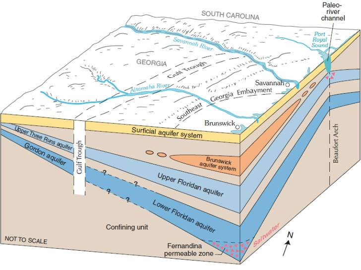
As you can see from the figure above taken from the Georgia Environmental Protection Division website, the area called the Beaufort Arch is where the problem exits. In the past when sea level in the Hilton Head area, including the Calibogue Sound west of the island, was lower ancient rivers cut right through the overlying rocks and formed channels. Later these channels filled with younger porous sediments. These channels can act as conduits for seawater to move downward into the Upper Floridian aquifer.
This might not sound like all that much of a problem, but because the Floridian aquifer was so overused on the southern coastal plain in Georgia it resulted in water in the aquifer moving from South Carolina towards the centers of pumping in Georgia. All sorts of towns and municipalities in Georgia, including Savannah and Brunswick, used the Upper Floridian aquifer as their main source of water. Before this large-scale groundwater development, freshwater in the Upper Floridan aquifer moved generally from inland recharge areas in South Carolina toward the coast and discharged upward or seaward. Under those natural conditions, artesian pressure helped keep saline water offshore or beneath the freshwater system. Hilton Head had increased vulnerability because the island lies close to Port Royal Sound, Calibogue Sound, and other saline surface-water bodies that overlie or border parts of the Floridan aquifer system there. It’s not all Georgia’s fault though, after all Hilton Head Island also was withdrawing water from the Upper Floridian which lowered the water table and reversed the aquifer’s natural seaward hydraulic movement. United States Geological Survey studies of Hilton Head have clearly shown how declining aquifer pressure changed the groundwater flow direction beneath the island. Instead of freshwater consistently moving toward Port Royal Sound, portions of the aquifer began moving landward.
To add insult to injury for the Floridian aquifer in Georgia, over pumping in the Brunswick area has caused another type of saltwater intrusion. The Upper and Lower Floridian aquifers are more integrated in that area because of faulting and fracturing in the rock formations. The Lower Floridian is not of high quality. Due to over pumping this low-quality saline water was drawn upward into the Upper Floridian aquifer. The problem is most significant in downtown Brunswick.
During the 1980s efforts began in Georgia to prevent saline waters from destroying the Floridian aquifer. Georgia began limiting water withdrawals from the aquifer in the most vulnerable coastal areas, especially around Savannah. The major turning point came in 1997, when the Georgia Environmental Protection Division adopted the Interim Strategy for Managing Salt-water Intrusion in the Upper Floridan Aquifer of Southeast Georgia. The strategy covered twenty-four coastal counties and imposed caps or reductions in areas where additional pumping could worsen saltwater movement. It required areas around Savannah to reduce groundwater use by at least 10 million gallons per day by the end of 2005 and limited new withdrawals in other parts of the coastal area.
Georgia replaced the interim strategy with the Coastal Georgia Water and Wastewater Permitting Plan for Managing Saltwater Intrusion in 2006. The plan instituted a more detailed management system for the Floridian aquifer. In the Savannah area where saltwater encroachment from the Hilton Head side was a central concern, the plan continued to limit Upper Floridan withdrawals and encouraged the shift to alternative sources, including surface water. Savannah now gets its’ water from the Savannah River. Smaller communities with no access to surface water have very restrictive limits on withdrawal and major water conservation measures are in place. In Brunswick where the saltwater plume was already wreaking havoc on water-quality, the plan preserved withdrawal restrictions. Brunswick has responded with conservation measures and drilling wells into less productive aquifers to supplement their water supply. And Hilton Head? Well, they have chosen to drill a very deep well into Eocene rocks. It’s poor water quality but they have added a desalination plant using reverse osmosis to treat it.
Is the Floridian in Georgia in water bankruptcy. I say no. Good management practices early on have disrupted such a catastrophe. This hydrograph from the USGS shows the rebound of water levels in Coastal Georgia after the institution of Georgia’s aquifer control measures.
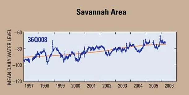
But the Floridian around Hilton Head in South Carolina might well meet the definition of water bankruptcy as once salinization occurs you’ve wrecked your water supply permanently.