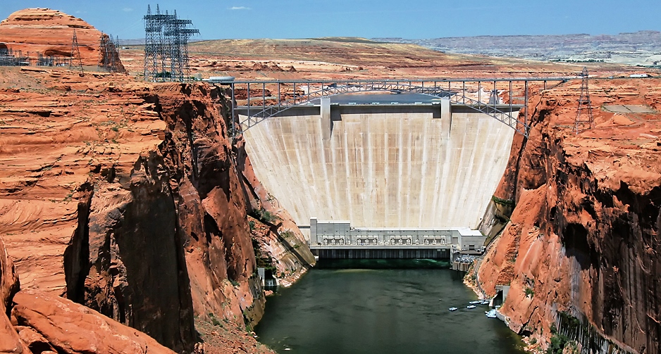
Glen Canyon Dam on Lake Powell in Page Arizona from Bureau of Reclamation files
The U.S. Bureau of Reclamation just issued a Record of Decision on hydrologic management of the Colorado River. It establishes a framework for operation of Lake Powell and Lake Mead. The framework is outlined in the Bureau’s Post-2026 Operational Guidelines and Strategies for Lake Powell and Lake Mead https://www.usbr.gov/ColoradoRiverBasin/post2026/final-eis/index.html. This document will replace the expiring Colorado River management agreements at the end of 2026.
Reclamation was hoping that the seven states which the Colorado River runs through and who are the primary users of the water from the river would come together and produce their own consensus-based agreement but of course that never happened, so the Bureau stepped in to make sure there was something to replace the existing agreements. The Bureau of Reclamation operates the dams on Lake Powell and Lake Mead so that is their main focus. There has to be enough water in the lakes to operate the dams. Period.
The west has been in drought conditions for years now and water levels in the lakes and in the whole reservoir system that the Bureau operates are dangerously low. Yet the lower basin states (California, Arizona, and Nevada) go blissfully on like nothing is happening. Out of control growth and overpopulation. It’s no wonder that the upper basin states of Wyoming, Utah, Colorado and New Mexico can’t make an agreement with these water hogs. Wallace Stegner the great American author wrote a book called Beyond the Hundredth Meridian that tells the tale of the whole development of western water management policy in the United States. It’s the story of John Wesley Powell whose first navigation of the whole of the Colorado River is legendary. Few people know though that Powell was the one who pushed for the western water management system that we have now. He told the idiots in Washington that there wasn’t enough water beyond the 100th meridian to support future western expansion and the idiots basically said, “so fix it.”
Now after years of drought and changes in climate conditions the truth of it all is apparent. It cannot be fixed. Even the new “operational guidelines and strategies” is admitting this because it relies on adaptive management practices. If you haven’t heard this term before, it means “an iterative method of decision making in the face of uncertainty.” Previously known quantities of water were scheduled for release on a yearly basis so water managers in states could plan. No longer. Now The ROD establishes operating guidelines through 2036 that will be determined in 2-year increments. What you get in 2027 may not be what you’re going to get in 2029, unless a broader consensus among the Colorado Basin States supports a longer duration (I’m personally not waiting for that to happen).
From what I can tell, 2027 will start with a range of possible releases of water from Lake Powell to the downstream Lower Basin States of 5.0 million acre-feet (maf) to 12.0 maf. This entails shortages for the Lower Basin of up to 3.0 maf. The Bureau plans water storage in Lake Powell of up to 8.0 maf and 3.0 maf in Lake Mead. The Bureau also is planning for voluntary Upper Basin conservation of up to 200,000 acre-feet (good luck with that).
I wrote a blog post many years ago about the poor old Colorado River and the stress that it was undergoing. You can read that post by clicking here An American River in Distress . I have been writing a lot about Water Bankruptcy recently. The definition of water bankruptcy is “the critical condition in which water resources are depleted or so severely mismanaged that they can no longer meet the essential needs of populations, ecosystems, and economies”. To read my post on Water Bankruptcy click on this link Is the World Really in Global Water Bankruptcy? . Is the Colorado River in Water Bankruptcy? This is a very good question. I’m going to attempt to answer that question in the next few months by looking at the recent hydrologic studies of the river. So as they say in the biz: “Stay tuned.”
The recently issued United Nations University Report Global Water Bankruptcy says: “The world is already in the state of “water bankruptcy”. In many basins and aquifers, long-term overuse and degradation mean that past hydrological and ecological baselines cannot realistically be restored. While not every basin or country is water-bankrupt, enough critical systems around the world have crossed these thresholds.”
Strong words and new words. What do they mean by “water bankruptcy?’ The term is defined in the report as the critical condition in which water resources are depleted or so severely mismanaged that they can no longer meet the essential needs of populations, ecosystems, and economies. The conclusion that we are now bankrupt is based on statistics. Very interesting. Not scientific proof, just statistics.
For example, the report says that nearly three-quarters of the world’s population live in countries classified as water-insecure or critically water insecure. Insecure is the mumbo jumbo word now used to mean insufficient. So, there is basically insufficient water for the population of these countries. The report also cites that about 4 billion experience severe water scarcity for at least one month a year.
Groundwater is reported to now be the source of 50% of global domestic water use and over 40% of irrigation water and that around 70% of the world’s major aquifers are showing long-term declining trends. Excessive groundwater extraction has in turn led to significant land subsidence because when you extract water and lower the water table, aquifer materials such as sand and silt compact. Compaction basically destroys the ability of the affected acquirer to recharge itself with water. The report says that over 6 million square kilometers—almost 5% of the global land area— is subsiding due to groundwater extraction.
Our biggest source of water though is surface water – rivers, streams, and lakes. They cite that a growing number of major rivers now fail to reach the sea (like the Colorado River – see my blog post here An American River in Distress ) or fall below environmental flow needs for significant parts of the year. No statistics are provided here; it’s just based on anecdotal observation. The report goes on to say that more than half of the world’s large lakes have lost water since the early 1990s, affecting around one-quarter of the global population that depends directly on them for water security.
Very interestingly the report states that about 70% of the world’s global freshwater withdrawals are used for agriculture and that more than 170 million hectares of irrigated cropland are under high or very high-water stress meaning again that there is insufficient water for irrigation at times.
So, what does the report say is the cause of global water bankruptcy? People. Of course, they couch it in terms of the “Anthropocene” the word now used to mean the period of time since humans have started affecting their natural environment with their activities.
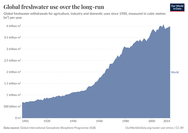
The chart I like best in the report is this:
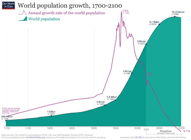
The chart shows the increase in freshwater use from the early 1900’s to today. Use rose precipitously starting in the 1960’s. They should have put the chart below right next to it because it shows an identical increase in population:
Trends indicate that by 2030, demand for water is expected to outstrip supply by 40 percent, driven by population growth, urbanization, and increased agricultural and industrial use. Apparently water bankruptcy will be the norm. However, the report provides no scientific measures for determining when a water system is in bankruptcy. Case studies are cited but there is no definitive presentation of a way to classify a system as bankrupt. In my view this is the big failing of this report. It only coins a new term and attempts to define it but lacks rigor in its presentation. So, the question still remains: are we in the midst of global water bankruptcy?
I will attempt in my blog to look into large water supply systems and determine if they are indeed in a state of bankruptcy. I will start with one of the most prolific aquifers in the United States – the Floridian.
Trivia question for you. What is the largest American river that does not empty into a sea? I’ll give you a hint. If you look down from the edge of the Grand Canyon, you’ll see this river twisting and winding its way through the scenic gorge it carved out of the mile thick rock layers on which you are standing. Yes, the answer is the Colorado River. Don’t believe me? Check out the photos in this U.S. Geological Survey fact sheet on the 2014 Bureau of Reclamation’s one-time historic release of water from reservoirs on the Colorado River (https://www.usgs.gov/news/a-river-ran-through-it-and-brought-life-least-a-while ), during which water finally reached the Sea of Cortez in Mexico. Water from the Colorado River has only reached the sea a couple of times since the 1960s. Why? Because, the Colorado River is not really a river anymore. It is just a 1450 mile long over engineered water supply ditch.
There are eight major reservoirs on the Colorado River. (Reservoirs are dammed structures that hold water). The Colorado has several famous reservoirs – Lake Mead behind Hoover Dam in Nevada and Lake Powell behind Glen Canyon Dam in Utah. In 2015, the eight reservoirs on the Colorado River were storing 30.2 million acre feet of water. Hydrologists and engineers use “million acre feet” as a way to measure water. An acre foot is around 326,000 gallons or essentially enough water to cover an acre of land with one foot of water. Currently, the reservoirs are at only 51 % of their capacity. Storage capacity for the reservoirs is about 60 million acre feet or somewhere around four years worth of the annual flow of the river. Yes that’s right the average yearly flow of the river over the last 100 years is about 16.4 million acre feet, so more water is being stored in reservoirs than flows down the river in a given year.
The water is released as needed during years when it is very dry and natural flow falls under the average. Forty million people depend on the water from the Colorado River for their water supply and farmers depend on the river’s water for irrigation. And that’s just the United States. There’s a treaty with Mexico that requires the U.S. to provide water to Mexico. So most years between all the users, the natural evaporation, loss of water to vegetation along the river, etc. the entire flow of the river is pretty much used up. Amazing as this may seem, the problem is only getting worse.
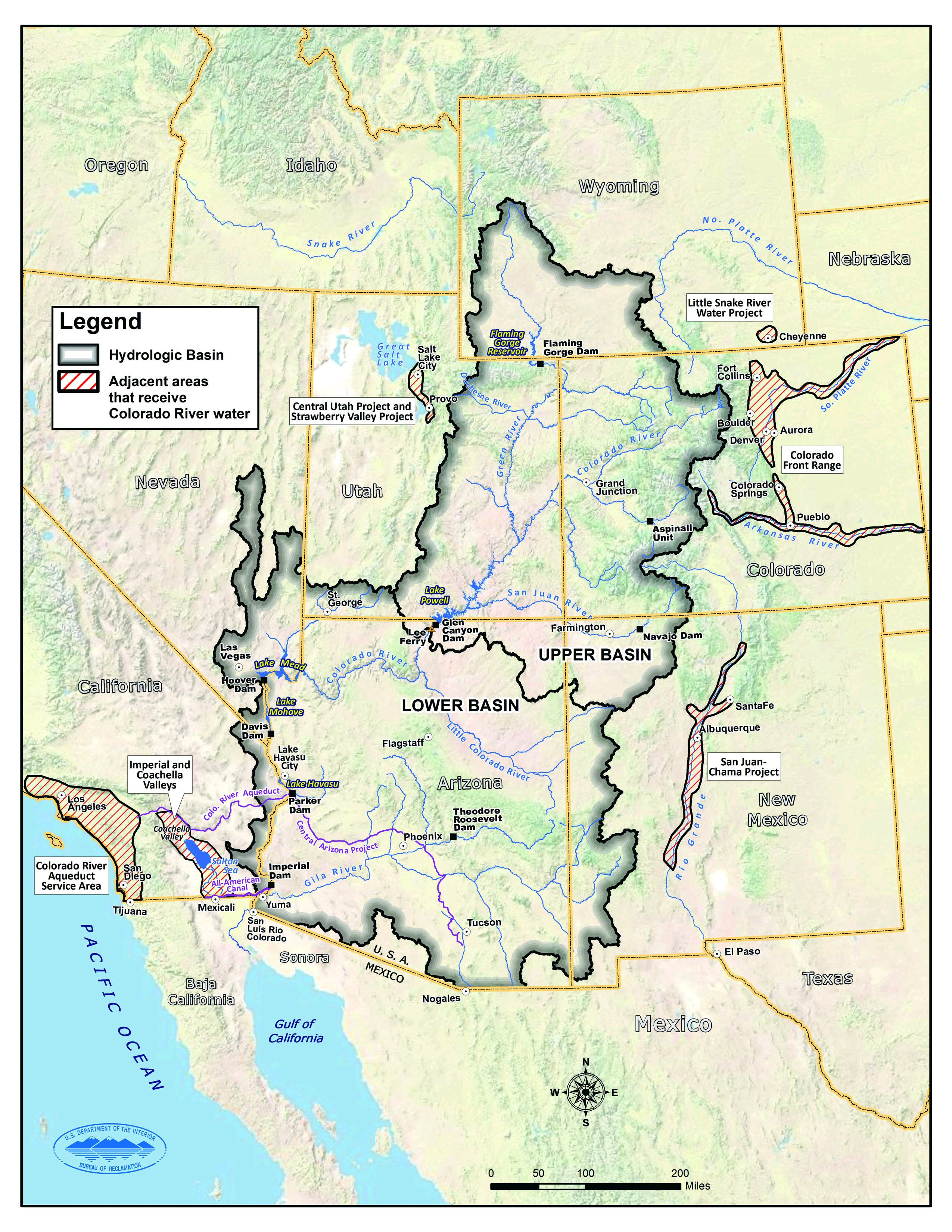
The Colorado River Basin is really big. When hydrologist’s talk about a basin they are talking about an area covered by all the tributaries of a river. This is a map of the Colorado River Basin.
Source: Managing Water in the West Colorado River Basin Water Supply and Demand Study, Bureau of Reclamation, December 2012
As you can see the basin encompasses seven states (Arizona, California, Colorado, New Mexico, Nevada, Utah and Wyoming) which are the driest in the country. Yet four of these states (Arizona, Colorado, Nevada and Utah) are among the top 10 states with the fastest growing population. This is a problem for water managers – a giant problem. They have to maintain water supply for domestic and industrial purposes, for agricultural irrigation and livestock watering, and for in-stream water flows to support wildlife and fish.
A federal agency – the Bureau of Reclamation – and the 7 Colorado Basin states manage the river’s water supply together. There has been a lot of head scratching by this group about the future water supply from the Colorado River. In fact, in 2012, the Bureau of Reclamation issued a report entitled: “Managing Water in the West: Colorado River Basin Water Supply and Demand Study.” The study looked at the future potential water flow in the river and the demands for that water all the way to the year 2060. I don’t usually cover engineering studies like the Bureau of Reclamation report in this blog, but the study is of interest because it seeks to inform decision-makers of the extent of future water supply deficiencies and options available to alleviate the deficiencies.
All sorts of decisions have been made in the past without studies. Case in point, in 1922 Herbert Hoover as Secretary of Commerce began the first in a series of decisions that would eventually make the Colorado River nothing more than a glorified pipeline for water supply eventually depriving the Sea of Cortez of a major source of fresh water flow. Hoover’s decision legally divided the Colorado River into Upper and Lower Basins using the point of Lee’s Ferry in Arizona as the demarcation line. All areas draining into the Colorado River above Lee’s Ferry are considered the Upper Basin, which includes Colorado and Wyoming and parts of Arizona, New Mexico, and Utah. The Lower Basin includes the areas draining into the Colorado River below Lee’s Ferry, encompassing the other parts of Arizona, New Mexico, Utah, and the entirety of Nevada and California. Hoover’s decision essentially gave 7.5 million acre feet of Colorado River water to each of the basins to be allocated by the states. Allocated means given a right to use the water. Ten other decisions from the 1920’s to the 1970’s form what is euphemistically called the “Law of the River” making the Colorado River one of the most regulated and controlled water bodies on the face of the earth with the sole purpose of providing water supply.
The 2012 Bureau of Reclamation study predicted possible future water supply from the Colorado River by looking at trends in the variability of the flow in the river. It looked at the historical record over the last hundred years, which is based on actual real life measurements of water flow and it looked at paleontological types of records, like tree rings, to estimate flow before measurements were kept. I think everyone knows that when you cut a tree, you see a cross section of rings. These rings can be wide or narrow depending on how much a tree grew in a particular season. If they are narrow, it indicates a dry season and the tree didn’t have much growth. A wide ring indicates a rainy period where the tree grew a lot. There are about a dozen other ways, besides tree rings, scientists use to reconstruct climate conditions. For example, scientists use ice cores from glaciers to determine rain and snowfall amounts and they use soil cores to determine the distribution of pollen and dust. This is all common sense stuff the average reader knows, when there’s more precipitation then glaciers grow, when there’s more rain then trees put out more flowers and pollen, when its dry then more dust and dirt blows around. So scientists can reconstruct the climate based on these paleontological types of data and show what the trends in stream flows were in the past. Such reconstructions are called paleo-reconstructed models of climate. The Bureau of Reclamation study developed a projected stream flow record for the Colorado River from a paleo-reconstructed model. For a third type of future water flow projection for the Colorado River, the study combined the trends based on paleo-reconstructed data with the trends based on measurements from the last hundred years. They described this projection as a paleo-conditioned scenario.
Very interestingly, the paleo-reconstructions of stream flow showed a great variability over the last 1250 years. In fact during the period between 762 and 2005 there were some hugely long dry periods of up to 16 years where stream flows were reduced beyond anything seen in recent times. Over the last 100 years there has been a general decline in stream flow. There has also been a major seasonal “shift” of when the most runoff enters the Colorado River. This shift is due to a decrease in the amount of spring snowmelt.
Projections of future water supply in 2060 from the river based on the various paleo-reconstructed models showed mean water flows of 14.7 to 15.0 million acre feet, similar to the current observed mean of 15.0 million acre feet. The study also made some projections based on the general circulation models for climate. These models are developed by the International Program on Climate Change sponsored by the United Nations. These projections were not good. Projected mean flows were around 13.7 million acre feet if temperature increases of between 1.3 and 2.4 degrees Centigrade occur – a decrease of 8.7 % from the current observed mean.
The real problem is not necessarily the amount of water available though, it is the projected future demand for water in the area. The study looked at possible future uses in the Colorado River Basin – population growth, agricultural growth, tribal water right settlements, increased energy production – and also looked at possible increases in future efficiency in water use. You know what efficient water use is – landscaping without grass and other water hungry plants, recycled water like you see at car washes now, low flow toilets, etc. Based on a number of variations in these different factors (for example normal population growth versus rapid population growth) the projected additional water in million acre feet needed from the amount used in the Basin area today ranged from 1 % to 3 %. But we’re talking total water use here, not just the water supply from the Colorado River. Some of those increases are going to come from other sources, mostly in Colorado and California.
Expected increased needs from the Colorado River are due mostly to increased population and industrial growth. The study anticipates municipal and industrial demands from the river will grow from the 3.4 – 3.5 million acre feet today to 4.5 – 6.2 million acre feet by 2060. The study projects another 3.2 million acre feet of water above the river’s projected mean annual flow will be needed by 2060. This is what water supply managers call an imbalance. There have been occasional imbalances of this magnitude in the past, but as you’ve learned, the reservoirs made up the deficiency. A prolonged imbalance will mean less water available to store in those reservoirs. The future doesn’t look bright for maintaining water supply in the Colorado River Basin without some big changes either in development of new water sources, like desalination of ocean water and importing water from other rivers in the U.S. through pipelines and via ocean going tankers, or massive water conservation and watershed management projects. In the end, the Colorado River becomes even less of a river and more of just a conduit for water supply. How far upstream will the trickle come to a stop?