
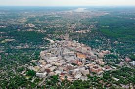
Have you been to Washington D.C.? It’s a favorite tourist destination for many. Most people who visit the city confine themselves to the National Mall where the monuments and historic sites can be seen. The downtown area is similar to other major cities, with extensive office blocks, condominiums, and small businesses like restaurants and retail stores, however Washington, D.C. is unique in never having had major industrial activity like manufacturing or refining as its economic engine is the federal government. Few who don’t live there realize the extent of the city’s surrounding suburbs. Urban sprawl stretches west to Manassas, Virginia, south to Fredericksburg, Virginia, north to Frederick and Baltimore, Maryland, and east to the Chesapeake Bay. The vast suburban enclaves wrapping themselves around the city’s core choke off the natural processes of the water cycle with their immense impervious surfaces of concrete, asphalt, and roof tiles. What is this unnatural environment doing to our precious water resources? A good look at the impact of this overdevelopment can be found in the 2019 U.S. Geological Survey (USGS) Scientific Investigation Report (2019-5092): Sediment and Chemical Contribution Loads in Tributaries to the Anacostia River.
The Anacostia River flows through Washington, D.C. and empties into the Potomac River. The USGS study is part of a larger scientific investigation of the Anacostia River’s pollution sources. The U.S. Environmental Protection Agency set Total Maximum Daily Load (TMDL) values for the Anacostia River in 2003 for 16 different pollutants. The goal of setting TMDLs is to make a water body comply with a determined use, which in this case is to make the Anacostia River both swimmable and fishable – a tall order even for a city without a lot of industrial activity. The few industrial sources of contamination have been identified. They consist of a power plant, a gas plant, a bulk fuel storage area, and a couple of city landfills. These sources have been studied and are well understood. Most of them now have control measures installed to prevent future pollution to the river. Contaminated sediments in the Anacostia from these sources have been pinpointed and singled out for removal so that they will no longer be a continuing catchment of contaminants polluting the river far into the future. However the question becomes: will the water in the Anacostia River meet the TMDLs set by the EPA after the removal of these old contaminant sources or will the urbanized environment just continue to pollute the river and make TMDLs unachievable? In other words, can the river be made clean again? Will people ever be able to safely eat fish from the river? Will they be able to swim and recreate in the river without concern?
Part of the continuing pollution of the river comes from the city itself. Storm and sewer drain studies have shown how the run-off from the city’s streets and yards are contributing to the pollution of the river. See my last post on Are Cities a Point Source of Pollution (Are Cities A Point Source of Water Pollution?) But what about the urbanized areas surrounding the city? What are their contributions? After all the entire city is small in comparison to the larger metropolitan area. The USGS study seeks to determine what the overall pollutant loads are from the tributaries of the Anacostia. The main tributaries with the largest basins and the greatest lengths are the Northwest Branch and the Northeast Branch. These branches are the two main tributaries which join to form the Anacostia River. The sources of both branches are in Maryland. The Northwest Branch drains much of the suburban areas of Montgomery County, Maryland while the Northeast Branch flows through Prince Georges County, Maryland. Both of these counties are monolithic representations of modern living with intense suburbanization, long streets clustered with parking lots, strip malls and shopping centers, residential developments with minimum space between houses and practically no yards, highways like the famous Beltway, and schools, churches and hospitals crammed into narrow spaces. Impervious surfaces, imposed by pavement and houses through which no rainfall can penetrate, vary from 20 percent in the upper portion of the basin to 50 percent at the confluence of the two branches. Both branch basins are densely populated. About 47 square mile out of a total 122 square mile area over which the tributary basins extend are covered with residential development. There are very few parks and any forest land is limited to that found along the riparian corridors of the branches. Just 13 square miles within the basins are forested. Agricultural lands make up only12 square miles. The two branches combined provide most of the water supply for the Anacostia River – 32,900 million gallons a year. They also contribute most of the sediment and the largest amount of Polyaromatic Hydrocarbon contamination flowing into the Anacostia. The USGS calculates that 89,000 grams of PAHs flow into the Anacostia from its tributaries every year. Seventy two percent of it comes from the Northwest and Northeast Branches. This is not surprising considering the urban nature of these two tributaries and the amount of sediment they are carrying. Out of 30,500,000 kilograms of sediment contributed by all tributaries to the Anacostia, 26,000,000 kilograms is coming from the Northwest and Northeast Branch with the Northwest Branch contributing the most. Considering that contaminants are primarily transported with fine grained sediment, it is not unexpected that the greatest amount of PAH contamination is coming from these two waterways.
Completely surprising is where the greatest amount of Polychlorinated Biphenyls (PCBs) is originating from – Lower Beaver Dam Creek. This tributary to the Anacostia originates solely from Prince Georges County, Maryland. Its basin is fairly small – 14.9 square miles – but it has an outsize contribution of sediment to the Anacostia, nearly 4,500,000 kilograms a year. This amounts to 3.01 kilograms per year for every square mile. Obviously Prince Georges County needs to put some erosion control measures into place. Entrained within the sediment is a huge load of PCBs being carried along by the water in the creek. The PCB levels in Lower Beaver Dam Creek are magnitudes greater than any other tributary to the Anacostia. The USGS calculated that stream water in the creek has an average concentration of 130 micrograms per kilogram. Compare that to Northwest Branch with 6.6 micrograms per kilogram. About half of the creek’s basin is covered in residential development. The impervious surface is estimated to be about 32 percent or 7 square miles. Forested land makes up only 3.5 square miles and agricultural land some 6.6 square miles. There’s also a small amount of industrial use (less than 1 square mile.) The source of the PCBs in the creek is not known. The total annual amount of PCBs calculated by the USGS as entering the Anacostia from its tributaries is 860 grams per year, seventy five percent of that is coming from Lower Beaver Dam Creek.
So how is this all going to affect the ability of current measures envisioned to protect the Anacostia River by removing known sources of PAHs and PCBs in the river’s sediments? And can the Anacostia River ever meet the TMDLs set by EPA? Well I suspect that’s all up in the air right now, because Northwest and Northeast Branch and Lower Beaver Dam Creek as well as a couple of smaller tributaries solely originating within Washington D.C. (Watts Branch and Hickey Run) are exceeding the contaminant load allocations set for those water bodies under TMDLs, in some cases by a factor of 200. What new measures will have to be implemented to control and reduce contaminants coming from the Anacostia River’s tributaries? And how will Washington D.C.’s environmental regulatory agency get cooperation from another state, in this case Maryland, to implement what could be costly and possibly disruptive practices to reduce contaminants that are essentially being introduced into waterways by suburban sprawl? If you want to know then look at the Chesapeake Bay Program where currently the state of Maryland is suing states upstream of the Susquehanna River that are contributing a huge share of the contamination to the Bay and doing little to prevent it. It’s clear from the USGS study that suburban areas, with dense populations creating extensive impervious surfaces (e.g. parking lots and streets), are a significant contributor to the contamination of streams and rivers. The runoff from paved surfaces after a rainfall is washing contaminants off suburban streets and transporting them into nearby streams. Additionally the heavy flow of water caused by runoff is eroding stream banks, resulting in a huge amount of sediment with entrained contaminants being carried downstream and into our rivers. The lack of natural rainfall percolation through soils is resulting in a new contamination source – the suburbs.